
Arsenic pollution in groundwater: another piece of the puzzle falls into place
John McArthur
Department of Earth Sciences, University College London
ECB Bulletin January 2009
Department of Earth Sciences, University College London
ECB Bulletin January 2009
Whilst the detrimental health effects of arsenic-contaminated drinking water may have receded from the headlines of late, the underlying geological causes of this human tragedy remain. Pioneering work by geologists and geochemists from University College London (UCL) on a mechanism for arsenic pollution in groundwater was reported in the ECG Newsletter at the turn of the last decade. Now as the first decade of the new century concludes, another mechanism for arsenic pollution has emerged, as Professor John McArthur from UCL explains.
River sediments and aquifers
River sediments: a source of drinking water. Rivers lay down sediment in floodplains on their way to the sea, and in deltas where they meet the sea. The sediment is often sandy and porous. After burial, such sands may form important underground reservoirs of freshwater (aquifers) that are exploited for domestic supply. Such aquifers are termed ‘alluvial’ or ‘deltaic’ because of their riverine origin. Groundwater from alluvial aquifers worldwide provides much of the world’s supply of drinking water. That drawn from the alluvial aquifers of Asian deltas—the Ganges/Brahamaputra, the Mekong, the Red River, the Irrawaddy, and many others—does so for a fifth of the region’s population.
Arsenic pollution of groundwater. In the 1970s, it was widely held that alluvial aquifers everywhere yielded wholesome groundwater. That notion led to the promotion, especially in Bangladesh and West Bengal, of the use of groundwater as a safe alternative to microbiologically-polluted surface water for domestic supply. But the groundwater in those countries was soon proven to be hazardous and affected by severe pollution by naturally-occurring dissolved arsenic. The problem was revealed successively in West Bengal, Bangladesh, Vietnam, and Cambodia, and is now known to occur in 30 deltaic and coastal aquifers worldwide (Ravenscroft et al., 2009 and references therein). It is clear that the pollution is severe and global in extent.
Levels of dissolved arsenic. By the term pollution is meant concentrations of dissolved arsenic that exceed local water-quality standards of 50 µg/L As, or the World Health Organization’s (2006) guideline value of 10 µg/L As. In many alluvial aquifers, arsenic concentrations of several hundred milligrams per litre are common in groundwater. Dissolved arsenic is odourless, tasteless, poisonous, and carcinogenic. Its danger lies in its long period of carcinogenic latency, which is measured in years to decades. As a consequence, in Bangladesh alone, the affect of natural As-pollution of groundwater was termed “the worst mass poisoning of a population in history” by Smith et al. (2000), who predicted that, by 2010, one in ten deaths in the area would be arsenic-related unless effective remediation alleviated the problem (ibid.).
|
The distribution of arsenic pollution
A mechanism for arsenic pollution. The natural As-pollution in Bangladesh was soon shown to derive from reductive dissolution of sedimentary iron oxide (FeOOH; Nickson et al., 1998 et seq.). Sediments contain iron oxides (often abbreviated to FeOOH) derived from mineral weathering and this FeOOH strongly sorbs arsenic. As long as some FeOOH remains in the sediment, arsenic remains sorbed to the FeOOH and arsenic pollution is absent from groundwater. But in sediments, microbial oxidation of organic matter commonly extracts from FeOOH the oxygen needed for C-oxidation, leaving the Fe(II), and its sorbed arsenic, free in solution as waste products. As a consequence, sands that retain FeOOH are not polluted by arsenic because the FeOOH sorbs it and prevents it appearing in solution. Where the FeOOH had been destroyed by reduction, arsenic pollution can be severe. Distribution of arsenic pollution. Whilst the mechanism of pollution is clear (albeit details continue to emerge), the factors that controls the distribution of the pollution are less clear. It was shown by Peter Ravenscroft, and his team at Mott MacDonald International in Dhaka and the University of Dhaka (DPHE 1999), to be patchy at all scales, from country-wide to village level (Figure 1). He also showed that sea-level change strongly influenced the distribution of As pollution, apparently confining it to sands deposited after a low stand of sea-level that occurred around 20,000 years ago. That was the time at which glacial ice, and the world’s ice-caps reached their maximum extent in the last ice-age, so the time is termed by geologists the Last Glacial Maximum (LGM; ≈20 ka). Ravenscroft showed that deep wells (mostly >150m deep) were arsenic-free because they drew water from old sand deposited before the LGM. |
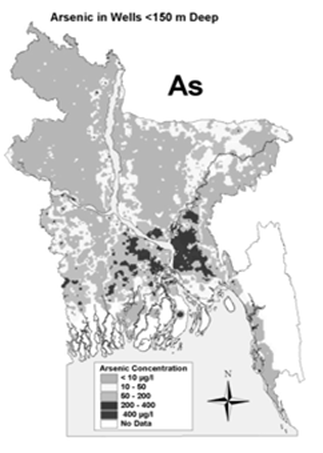
Figure 1: Distribution of arsenic pollution in Bangladesh.
The map shows the average (or most probable) arsenic
concentration in the upper 150 m of the alluvial
aquifer system
|
A new model for arsenic pollution. Whilst the work of Ravenscroft’s team explained why deep wells were not polluted by arsenic, it did not explain why some 25% of wells drawing water from younger sands were arsenic polluted, and 75% were not. This arsenic pollution is patchy: of two wells within metres of each other, one might be arsenic-free whilst the other is polluted with arsenic. There had to be more to the story. Another piece of the jigsaw has just been put in place by a paper published by the London Arsenic Group (McArthur et al., 2008). The group undertook extensive drilling and shallow geophysical measurements of sediment resistivity in order to understand what it was in the subsurface that gave this patchy distribution of arsenic, and they appear to have discovered the reason. As a result, the paper has set forth a new model of arsenic pollution that may explain the patchy distribution of arsenic in the groundwater of the Bengal Basin and so in deltaic aquifers worldwide where arsenic pollution occurs.
|
The palaeosol model of arsenic pollution
Palaeosol formation. The model sets As-pollution in the context of sea-level change, weathering, and the formation of ancient soils (termed palaeosols) by continental weathering. Sea-level decreased in level by about 120 m between 125 ka and 20 ka, as the last ice-age developed to its maximum. Falling sea-level exposed the world’s coastal areas to subaerial weathering. In deltas worldwide, this lowering caused rivers to incise into the exposed coastal plains to maintain their base levels as close as possible to sea-level. The exposed regions between the rivers, termed the interfluves (Figure 2) were not eroded by rivers but were weathered subaerially and developed a capping of impermeable clay soil, termed a palaeosol (Figures 2 & 3). Sands underlying the palaeosol were also weathered by oxygenated groundwater flowing through them. The sands were turned brown in colour as they became FeOOH rich. This weathered, oxidized, and eroded, landscape was buried by later (post LGM) sediments as sea-level rose between 20 ka and 6 ka to near its present level, pushing the sea-shore landward, backing up the rivers, and making them deposit their sediment load so as to build the modern delta we call Bangladesh. In the Bengal Basin, the sediments included organic-rich silts and muds to drive FeOOH-reduction and cause As-pollution in these post-LGM sands. Palaeosols influence arsenic distribution. The key postulate of the ‘palaeosol model’ is that the weathering of interfluves between 125 ka and 20 ka capped the oxidised Pleistocene brown sands with an impermeable palaeosol, termed the Last Glacial Maximum Palaeosol (LGMP). The LGMP formed regionally, if discontinuously, and has a major impact on groundwater flow (Figure 3), thus controlling the distribution of As-pollution. The LGMP controls flow because it is impermeable. |
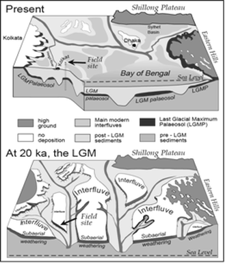
Figure 2: Schematic of palaeosol development on palaeo-interfluvial areas of the Bengal Basin between 125 ka and the last glacial maximum at 20 ka. The palaeosol is here termed the Last Glacial Maximum Palaeosol, or LGMP. Arrows show the location of the detailed cross section in Figure 3. The size of interfluves is schematic only; their true extent and degree of continuity is unknown
|
Potamology, palaeosols and arsenic. The LGMP prevents vertical recharge reaching brown-sand aquifers beneath the palaeo-interfluves (Figure 3) and so protects them from both downward percolation of As
polluted water, and also from downward migration of organic matter (OM), from overlying OM-rich sediments, that would drive reduction of FeOOH and cause As-pollution. A consequence of this prevention of vertical flow is that FeOOH in palaeo-interfluvial aquifers has suffered little reduction, and the sands remain today both brown and FeOOH-rich, so their groundwater is As-free. In contrast, the old river channels, now buried and so termed palaeo-channels, contain no LGMP, either because it was never deposited in active river channels, or because it was removed after formation by post-LGM erosion (Figures 2 and 3). Palaeo-channels contain no barrier to downward flow of arsenic or organic matter so both have moved downwards in them to both pollute and reduce FeOOH in underlying sands of all ages.
|
The LGMP prevents vertical flow, but not horizontal flow, so why do palaeo-interfluvial aquifers of brown sand exist some 6,000 years after basin-filling largely ceased as sea-level reached its present level? Why have the palaeo-interfluves not been invaded laterally by arsenic to pollute, and by organic matter to reduce FeOOH (Figure 3) and further pollute? More importantly, if it has not happened by now, will it ever: will such aquifers always be safe from lateral invasion by pollution?
One reason for the survival of palaeo-interfluvial brown sands is that their depth of >20m is below base-level. The elevation of much of the deltaic regions of the world is close to sea-level; in the Bengal Basin, the elevation of the land is typically only 5 to 10 metres above sea-level. Because of this low elevation, water at 20m depth below ground level is below sea-level. At such depth where the topography is flat, as it is in deltas, flow is slow because no hydraulic head exists to drive it. |

Figure 3: The LGM palaeosol and its effect on groundwater flow. Section across the field site shown in Figure 2. Open arrows show groundwater flow direction; size denotes flow magnitude. The LGMP prevents vertical recharge to brown sands beneath it, so preserving them as unpolluted aquifers. Horizontal flow moves organic matter (to reduce FeOOH) and arsenic (to pollute) into the brown sand aquifer beneath the LGMP, thereby threatening the palaeo-interfluvial aquifer
|
With little flow, palaeo-interfluves suffered little lateral invasion by pollution. What little occurred would, for arsenic, have been retarded by sorption to FeOOH in brown, palaeo-interfluvial sands. Organic matter would have been retarded by reaction with FeOOH, with the arsenic released being re-sorbed immediately downflow (Welch et al., 2000).
But since the introduction of pumping of groundwater for irrigation in the 1970s, groundwater flow to even 30 m depth is no longer natural or slow; both velocity and flow-depth have increased; subsurface flow is now strong. In the McArthur et al. field area (Figure 4), irrigation pumping has reversed the natural southerly flow direction, which is now northwards, from As polluted palaeo-channels into unpolluted palaeo-interfluves (Figures 3 & 4). This modern flow carries pollution into the palaeo-interfluvial aquifers. The invading pollution/redox front threatens the reserves of good-quality groundwater present in palaeo-interfluvial areas. Movement of the front is the reason why wells positioned near it (e.g. Ba 2, 13; Figures 3 and 4) have changed their As-concentration with time, some increasing as the front approached and some decreasing after it had passed.
But since the introduction of pumping of groundwater for irrigation in the 1970s, groundwater flow to even 30 m depth is no longer natural or slow; both velocity and flow-depth have increased; subsurface flow is now strong. In the McArthur et al. field area (Figure 4), irrigation pumping has reversed the natural southerly flow direction, which is now northwards, from As polluted palaeo-channels into unpolluted palaeo-interfluves (Figures 3 & 4). This modern flow carries pollution into the palaeo-interfluvial aquifers. The invading pollution/redox front threatens the reserves of good-quality groundwater present in palaeo-interfluvial areas. Movement of the front is the reason why wells positioned near it (e.g. Ba 2, 13; Figures 3 and 4) have changed their As-concentration with time, some increasing as the front approached and some decreasing after it had passed.
|
To quantify the threat posed by the irrigation-induced migration of arsenic, it will be necessary to determine the rate at which arsenic and organic matter (to cause FeOOH reduction) in the front are moving, and how effective the brown sand of the palaeo-interfluves is at sorbing arsenic. Current estimates are that the front is moving at around 1–5 metres per year, and McArthur and his team have just received funding to undertake further studies to improve these estimates. The factors controlling the rate of As-migration must be quantified as they will determine the lifetime of unpolluted palaeo-interfluvial supplies. What is sure is that the reserves of low-As water extractable from palaeo-interfluves will exceed the aquifer volume because invading As-polluted water loses arsenic by sorption to brown sands as it enters the palaeo-interfluves, which act as giant, in situ, As-removal filters. A knowledge of the rates of As-pollution will be applicable, within broad limits, to aquifers worldwide, albeit modified by local hydrogeological factors.
|
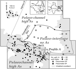
Figure 4: The study area of McArthur et al (2008), and the distribution of arsenic in the shallow groundwater (<50m depth): flow is to the NNE. A palaeo-interfluve, defined by drilling, well-mapping, and geophysics, is flanked on W, N, and S (E is unknown) by As-polluted palaeochannels. Along the S edge of the interfluve, a redox/As front is moving NNE in response to groundwater flow, and has increased the As-content of Well Ba 13, and decreased it in Well Ba 2, since 2002
|
The implications of the palaeosol model beyond the Bengal Basin
Because the decline in sea-level from 125 to 20 ka was eustatic and so worldwide, palaeosol formation was also worldwide in deltaic aquifers. It is therefore no surprise that the LGMP has equivalents in other deltas where arsenic pollution is extensive e.g. in western India, the Red River Basin of Vietnam, and the Po Valley of Italy (references in McArthur et al., 2008). The LGM palaeosol is also widespread in shallow-marine settings that were subaerial during the LGM (e.g. Yellow Sea, South China Sea, Sunda Shelf) thus attesting to its widespread occurrence.
If correct, the ‘palaeosol’ model will provide a conceptual framework within which to understand the distribution of pollution, not just pollution by arsenic, in most, if not all, deltaic aquifers, worldwide, as the eustatic lowering of sea-level, and associated weathering of the exposed coastal areas, affected all deltas between 125 ka and 18 ka. The ‘palaeosol model’ also requires a change in the concept of flow in deltaic aquifers away from a view that pollutants (and not just arsenic) migrate vertically downwards over wide areas, towards one where flow is mostly horizontal until intercepted by a local palaeo-channel, at which point it will be concentrated to flow vertically downward in the high permeability palaeo-channel. That understanding will underpin exploration and exploitation of shallow, low-As, sources of water across the Bengal Basin and more widely, and prove useful to all those involved in water-quality monitoring and health surveys.
References
DPHE (1999), Groundwater Studies for Arsenic Contamination in Bangladesh, Mott MacDonald International Ltd, BGS, Department of Public Health Engineering (Bangladesh) and Department for International Development, UK (6 volumes). See also http://www.bgs.ac.uk/arsenic/bphase1/b_intro.htm
McArthur, J. M.; Ravenscroft, P.; Banerjee, D. M.; Milsom, J.; Hudson-Edwards, K. A.; Sengupta, S.; Bristow, C.; Sarkar, A.; Tonkin, S.; Purohit, R. (2008), How paleosols influence groundwater flow and arsenic pollution: A model from the Bengal Basin and its worldwide implication, Water Resour. Res., 44, W11411, doi:10.1029/2007WR006552.
Nickson, R. T.; McArthur, J. M.; Burgess, W.; Ahmed, K. M.; Ravenscroft, P.; Rahman, M. (1998), Arsenic poisoning of Bangladesh groundwater, Nature, 395, 338.
Ravenscroft, P.; Brammer, H.; Richards, K. S. (2009), Arsenic Pollution: A Global Synthesis, Blackwell-Wiley, Oxford, 2009.
Smith, A. H.; Lingas, E. O.; Rahman, M. (2000), Contamination of drinking-water by arsenic in Bangladesh: a public health emergency, Bulletin World Health Org., 78 (9), 1093–1103. Available on the web at http://www.who.int/bulletin/archives/78(9)1093.pdf
Welch A. H.; Westjohn, D. B.; Helsel, D. R.; Wanty, R. B. (2000), Arsenic in groundwater of the United States: occurrence and geochemistry, Ground Water, 38, 589–604.
World Health Organization (2006), Guidelines for Drinking-water Quality: Ch 8,: Vol. 1, Recommendations. 3rd edn.
JOHN McARTHUR
Department of Earth Sciences, University College London, Gower Street, London UK WC1E 6BT
Home page: www.es.ucl.ac.uk/people/mcarthur/
London Arsenic Group: www.es.ucl.ac.uk/research/lag/as/
Acknowledgement: Figure 1 was prepared by Peter Ravenscroft using data collected during the “Groundwater Studies for Arsenic Contamination in Bangladesh” project during 1998 and 1999. This project was funded by DFID on behalf of the Bangladesh’s Department of Public Health Engineering (DPHE), and carried out by Mott MacDonald Ltd and the British Geological Survey. Further maps of arsenic distribution in Bangladesh may be seen at www.es.ucl.ac.uk/research/lag/as/pdf/BangladeshArsenicMaps.ppt